
Training of technical staff about ArcGIS in planning and management of groundwater (28/9/2009-09/10/2009)
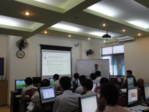 A GIS training course has been carried out in Geo-Viet TrainingCenter in Hanoi from 28th of September to 9th of October 2009. The objectives of the training was to broaden the knowledge and to improve the skills of 17 participants in GIS technology and its application in groundwater planning and investigation. Participants have been selected from the young and competent staffs from 4 Provincial Departments of Natural Resources and Environment targeted by the Project namely Ha Noi, Nam Dinh, Ha Nam and Soc Trang and the Center for Water Resources Planning and Investigation and its three divisions of the North, the South and the Centre.
Generally, the lectures were about the introduction of the GIS software and its basic functions: displaying and editing the database in ArcGIS; the functions of processing and analyzing of ArcGIS, results and use of GIS applications with practical exercises in small projects of groundwater, mapping, editing and printing. The teaching methodology combined ArcGIS theory and its applications to the actual case study Nam Dinh.
The training of ArcGIS was one of the most important stages to improve the capacity for the people working with I.T of CWRPI and the DONREs. The ten-day of intensive working with tremendous commitment of the both learners and teachers brought out a great result. All of the trainees passed the final test with the minimum score of 60/100. Remarkably, more than 50% of the learners get an excellent point of 95/100.
Presence at both of the opening and closing ceremony of the course, Doctor Do Tien Hung – Director of the Center for Water Resources Planning and Investigation openly expressed his satisfaction for the result of the first training. He considered the training course as one of the initial achievements in capacity building in frame of the Project. Further trainings for the technical staffs are planned.