
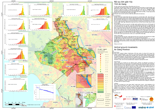
Map series: land subsidence in the Mekong Delta by provinces
- Version
- Download
- File Size 134.00 MB
- File Count 14
- Create Date Thursday November 28th, 2019
- Last Updated 02.06.2026
Map series: land subsidence in the Mekong Delta by provinces
The Vietnamese Mekong Delta is one of the world’s hot spots in terms of danger of inundation of large parts of land due to the effects of sea level rise on one hand; and land subsidence on the other hand. Estimating, understanding and projecting land subsidence and its causes and impacts on future developments requires up to date and comprehensive regional data, which was not available for the Mekong Delta at the onset of activities in early 2019. In order to bridge this data gap, GIZ and BGR in Vietnam joined forces with the German Federal Office of Civil Protection and Disaster Assistance (BBK) to activate the EU Copernicus Emergency Management Service (CEMS) with the purpose to:
- provide spatially and temporally consistent and dense results of InSAR-derived deformation rates (average land subsidence velocity) for the entire Vietnamese Mekong Delta,
- utilize the obtained data-set to gain further insights into the characteristics (distribution and variance in space, dynamics in time), drivers and impacts of land subsidence phenomena,
- generate a series of derived products for dissemination and awareness raising among national and international stakeholders, and for the consideration and integration of findings in regional and provincial planning processes.
Technical data processing was commissioned by EU CEMS under its Risk and Recovery program to technical specialist companies Indra & GISAT with the project ID “EMSN-062: Assessing changes in ground subsidence rates, Mekong Delta, Vietnam” in spring 2019. All processing works were closely accompanied by GIZ and BGR experts in Vietnam, who also delivered input data and reviewed interim results. The final data-set as well as a final report with technical information on data sources, data processing, validation procedures and results is publicly available on the CEMS website (see products below). The data set delivered by CEMS was then utilized by GIZ and BGR, its national partners in Vietnam, associated research initiatives and a series of other projects for specific analysis and preparation of derived products, such as on flood modelling and drainage planning (GIZ), and the investigation of causes of land subsidence in the delta (BGR). Results from the data set are also incorporated in the new Master plan for resilient development of the Mekong Delta by the Vietnamese government.
This map series was prepared by GIZ and BGR and shows PS, interpolations and variance for each province, based on the EMSN-062 dataset.
Attached Files
| File | Action |
|---|---|
| Vinh Long Province, land subsidence, GIZ, BGR, Nov 2019.png | Download |
| Tra Vinh Province, land subsidence, GIZ, BGR, Nov 2019.png | Download |
| Tien Giang Province, land subsidence, GIZ, BGR, Nov 2019.png | Download |
| Subsidence Mekong Delta, 29 Oct 2019, bi-langual, 600dpi.jpeg | Download |
| Soc Trang Province, land subsidence, GIZ, BGR, Nov 2019.png | Download |
| Long An Province, land subsidence, GIZ, BGR, Nov 2019.png | Download |
| Kien Giang Province, land subsidence, GIZ, BGR, Nov 2019.png | Download |
| Hau Giang Province, land subsidence, GIZ, BGR, Nov 2019.png | Download |
| Dong Thap , land subsidence, GIZ, BGR, Nov 2019.png | Download |
| Can Tho Province, land subsidence, GIZ, BGR, Nov 2019.png | Download |
| Ca Mau Province, land subsidence, GIZ, BGR, Nov 2019.png | Download |
| Ben Tre Province, land subsidence, GIZ, BGR, Nov 2019.png | Download |
| Bac Lieu Province, land subsidence, GIZ, BGR, Nov 2019.png | Download |
| An Giang Province, land subsidence, GIZ, BGR, Nov 2019.png | Download |