
Groundwater abstraction maps for the Mekong Delta in 2017
- Version
- Download
- File Size 32.20 MB
- File Count 2
- Create Date Friday May 28th, 2021
- Last Updated 02.06.2026
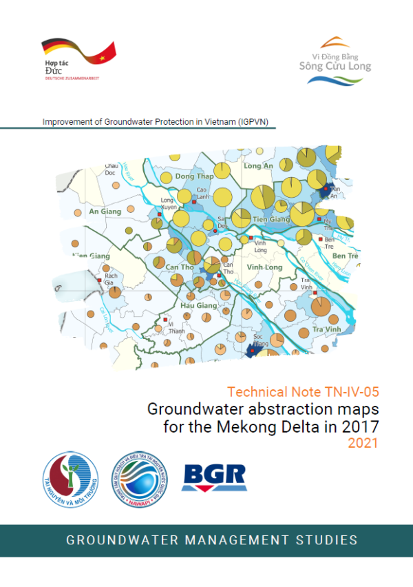
Technical Note TN-IV-05
Groundwater abstraction maps for the Mekong Delta in 2017
2021
The knowledge of amount and location of groundwater abstractions is a vital component and a legal requirement for the management of groundwater resources in the Mekong Delta, where recharge of groundwater is thought to be limited. As groundwater abstractions and corresponding data sets are changing by the year, a static map or large tables representing the abstraction status at one point in time is not adequate for the groundwater management tasks. Also, aggregated tables at provincial or district level are insufficient to capture spatial differences.
To gain an overview of licensed abstractions on a delta-wide scale, the IGPVN project has now produced a series of groundwater abstraction maps to:
- improve the overall knowledge on licensed groundwater abstractions,
- enable grasping the spatial differences in abstraction rates and aquifers used,
- allow comparison between administrative units by using the abstraction density down to commune level, and to
- design a visualization scheme that can easily be updated with newer data (see section 2.2).
The Technical Note TN-IV-05 is accompanied by a total of ten maps:
- licensed groundwater abstraction density (m³/d per km²) over all aquifers for district level with pie-charts for tapped aquifer at (1) province / (2)district level,
- licensed (3) groundwater abstraction density (m³/d per km²), (4) total groundwater abstraction rate (m³/d) and (5) number of wells over all aquifers for commune level
- licensed abstraction density (m³/d per km²) for single aquifers (6) qp2-3, (7) qp1, (8) n22, (9) n21, (10) n13 at commune level.