
3D Hydrostratigraphic Model for the Mekong Delta in Vietnam – Region South of Hau River
- Version
- Download
- File Size 14.31 MB
- File Count 1
- Create Date 28/05/2021
- Last Updated 02.06.2026
Technical Report TR-IV-04
3D Hydrostratigraphic Model for the Mekong Delta in Vietnam - Region South of Hau River
2021
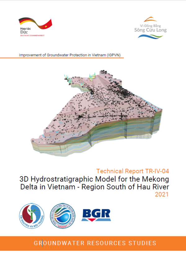
A three-dimensional solid model of the hydrostratigraphy is a visual tool for the assessment of the hydrogeological situation of the study area. With a 3D hydrostratigraphic model, one can easily generate hydrogeological cross-sections, well logs in any interested transect or location, or build maps of aquifer and aquitard thickness using GIS. The purpose for this specific 3D model was to improve the understanding of the subsurface for the region South of Hau River by significantly increasing, compared to previous studies, the number of used borelogs for building the model, thus also allowing to detect vertical hydrogeological windows.
The basis of the 3D model are 361 reliable well logs, of which 72 reach the lowest aquifer n13 and 44 reach the bedrock. All hydrogeological units were verified and (if needed) re-stratified into the corresponding aquifer or aquitard. A surface truncation method in combination with the ArcGIS IDW interpretation method was applied for the creation of top and bottom surfaces of each hydrological unit.
The outcome of this modelling work include:
- a GIS database with point data of all well logs,
- 15 raster files of top and bottom of 14 hydrogeological units,
- a 3D hydrostratigraphic solid model with 3D shapefiles.
Even though the density of reference points (logs) is much higher than in previous models and the stratigraphy is quality controlled, the precision of the model is still limited as original lithological descriptions were not available, grain-size analysis is based on hand-tests and the geological age is only measured for a small number of locations. In addition, the model is based on the existing hydrostratigraphic concept, borelogs are not evenly spaced and only 44 wells actually reached the bedrock, so local heterogeneities cannot be depicted. Evaluation of modelling accuracy showed that errors are highest in areas with a high lithological heterogeneity over short distance, e.g. in the urban areas.
The Technical Report TR-IV-04 describes in detail how the 3D hydrostratigraphic model and its accompanied GIS database were built for the Southern Hau River Region and gives orientation for its potential use. In addition to the report itself, the product contains a wealth of digital files.
Attached Files
| File | Action |
|---|---|
| TR-IV-04_3D model_EN_comp.pdf | Download |